P 1
Observation and investigation of the land-atmosphere system, atmospheric boundary layer processes, and fluxes
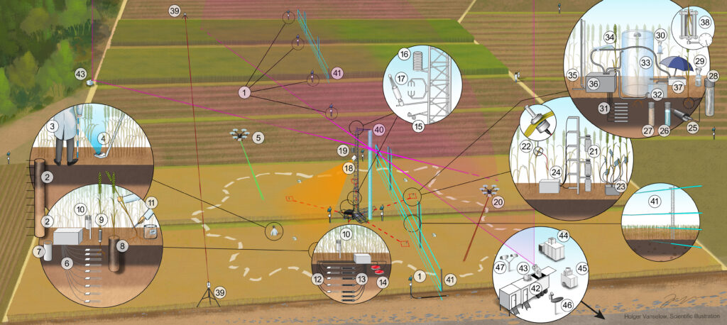
The characterization of Land-Atmosphere (L-A) feedback processes requires detailed studies of the soil, the vegetation, and the atmosphere up to the lower free troposphere encompassing the atmospheric boundary layer (ABL). Almost all current observatories and observational networks focus only on subcomponents of the L-A system. The objective of project P1 is to realize a prototype Land-Atmosphere Feedback Observatory (LAFO) over heterogeneous farmland at the University of Hohenheim that closes these observational gaps. LAFO will permit the simultaneous profiling of key variables in all three compartments and the characterization of their interactions in a heterogeneous landscape. Moreover, we will analyze a 20-year data set collected at the MOL-RAO of the DWD covering the most relevant L-A system variables for the derivation of statistical L-A feedback metrics, surface fluxes, and the energy-budget closure with special emphasis on extreme conditions (exceptionally wet and dry years / seasons).
In particular, P1 bundles all experimental activities of the FOR: In 2025, we will perform a comprehensive field measurement program to characterize L-A feedback processes at LAFO over at least one vegetation period (March – October). Besides well-established measurement techniques such as flux chambers, eddy-covariance systems and Doppler lidar systems we will further employ new techniques. These include water isotopic sensors for differentiating between evaporation and transpiration, fibre-optic distributed sensing in the soil, in the canopy, and in the surface layer (SL) for temperature and wind measurements, unmanned aerial vehicles to map land surface and vegetation properties, operation of an optical-microwave scintillometer system to estimate area-representative values of the surface sensible and latent heat fluxes, and high-resolution scanning Raman- and differential absorption lidar systems together with Doppler lidars to derive 3D turbulent properties of the SL and the ABL with special emphasis on entrainment processes.
As such, P1 is of immediate relevance to all other subprojects of the FOR. P2-P6 will analyse the collected data under different scientific aspects, P7-P9 will model the whole observation period and use the P1 data for comparisons of feedback metrics and process representations as well as model verification. P10 will analyse the MOL-RAO long-term and the LAFO data using machine-learning methods. The measurements performed in P1 provide the essential basis to reach the objectives and to address the hypotheses of LAFI. Similarly, all cross-cutting working groups rely on the observations of P1.
P 2
Remote sensing of vegetation canopy properties: States & spatio-temporal dynamics
Especially the influence of vegetation canopy properties and their spatio-temporal dynamics on feedbacks between the land surface and the atmosphere (i.e., temperature, precipitation, humidity, atmospheric boundary layer properties) are not conclusively understood. One major reason for this is that high-resolution observational data products (c.f. on vegetation canopy moisture) are not available yet at high spatial resolution (decameter scale) and on multi-year time scales: neither from remote sensing nor from models. In addition, land surface heterogeneities (e.g. variety in vegetation cover) can have significant impacts on feedback processes between canopy and proximate atmosphere, but their representation in models is not sufficient at high spatial resolutions. To bridge these gaps, remote-sensing based products are being developed to account for some of the multiple varying vegetation conditions.
In that sense, the idea of Project 2 is to monitor a range of vegetation canopy properties, encompassing water content pools (e.g., soil and vegetation moisture) and fluxes (e.g., evapotranspiration) at both field (link to in situ data) and regional (link to earth system model data) scales. The approach takes advantage of the potential synergies among optical, passive and active microwave sensors, which offer complementary information to transform remote sensing signals (e.g., microwave attenuation) into biophysical variables (e.g., gravimetric vegetation moisture, evapotranspiration, or vegetation structure and density). These unique and unprecedented datasets of satellite-based multi-sensor remote sensing will be fed into land-atmosphere (L-A) models to determine and analyze boundary layer properties and L-A feedbacks. All these land surface variables can synergistically contribute to understanding the link between soil, vegetation and the atmospheric boundary layer processes and to initialize L-A models.
P2 directly focuses on the high-resolution (decameter-scale) determination of states and spatio-temporal dynamics of the moisture, temperature and topography of the vegetation canopy to track moisture and temperature distributions for assessing transpiration and the shape as well as 3D-dynamics of the atmospheric roughness sublayer. This is achieved by blending of multi-sensor remote sensing observations (e.g. Copernicus Sentinel satellites & space-borne LiDARs). Spatio-temporally dynamic information of these vegetation variables will be prepared for integration into the fleet of land-atmosphere models of LAFI for assessing boundary layer properties and understanding of L-A feedbacks.
P 3
Using real time water stable isotope in-situ measurements to partition evapotranspiration into soil evaporation and plant transpiration at two distinct cropland sites
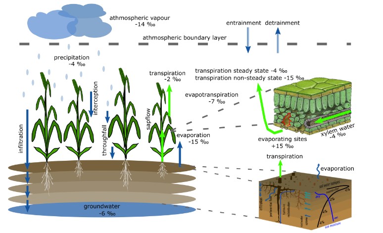
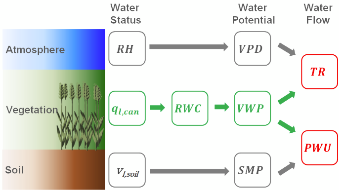
The subproject P3 will perform measurements of water fluxes and their isotopy within the land-atmosphere system to investigate water-related processes with high temporal and spatial resolution (e.g. using canopy and leaf chambers for evapotranspiration and transpiration and membrane probes for soil water isotope measurements). These coupled measurements will result in a novel isotope measurement platform that will allow us to systematically determine the contribution of different soil depths to root water uptake and root water uptake patterns of two crops (maize and wheat) at LAFO. In addition, water transit times will be determined and evapotranspiration partitioning will be performed and evaluated using the isotope data collected.
P 5
Investigating the impact of land surface heterogeneity on near- surface circulations and fluxes
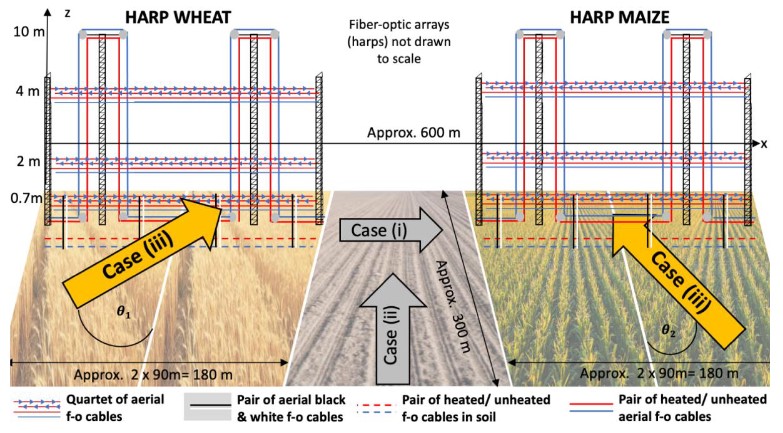
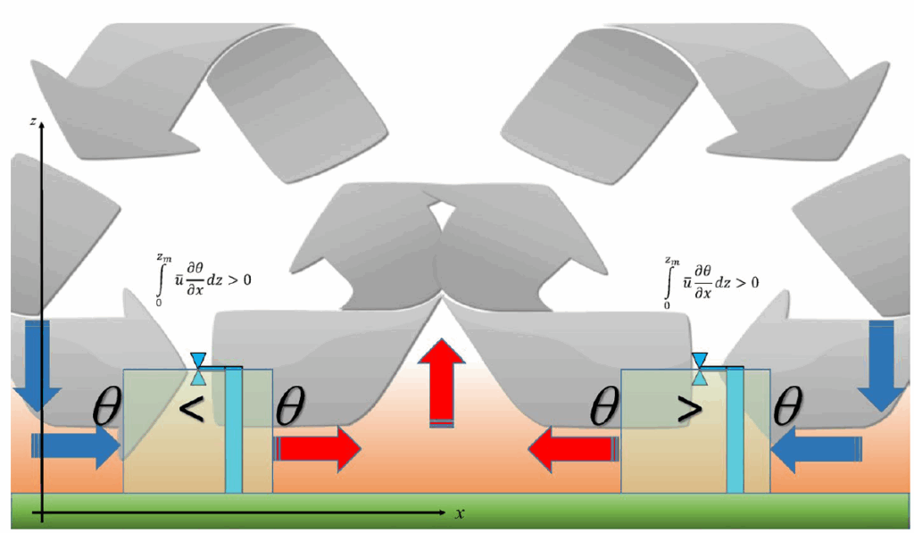
Project P5 is motivated by the need to compute biophysically meaningful surface heat and momentum budgets for heterogenous land surfaces as an essential component in the L-A feedback chain. Over the past decades, progress in understanding and quantifying the impact of surface heterogeneity has been made for the canonical cases of perpendicular and parallel airflows relative to a heterogeneity jump. In contrast, the turbulent structures for the most common case of oblique airflows, here defined as attack angles between 10° and 80° relative to the patch edge, are not mechanistically understood and their impact on surface fluxes escapes quantification. P5’s objective is therefore to detect, understand, and conceptualize these oblique airflows moving across LAFO’s agricultural patches. Our central hypothesis is that zones of enhanced surface fluxes through localized but non-stationary turbulent motions create a transitional boundary layer in which area-averaged fluxes are inflated and enhance L-A feedbacks.
We analyze spatially explicit measurements from high-resolution fiber-optic distributed sensing (FODS) of air temperatures in the surface and crop layers, wind speed and turbulence kinetic energy on scales of seconds and decimeters over hundreds of meters. FODS also observes soil temperature and moisture, and the distribution of solar radiation at scales of decimeters and tens of seconds combined with classic sensor networks above the patches planted in winter wheat and maize.
P 6
Investigations of ABL dynamics and structure over heterogeneous surfaces with turbulence-resolving simulations (LES)
Traditionally, transport in the atmospheric boundary layer is quantified based on a turbulence theory that relies on the assumption of horizontally homogeneous flow. This allows for a local description through one-dimensional fluxes in the vertical direction. While this assumption may hold for small-scale turbulence near the surface, it is well-known that sub-mesoscale transport processes often constitute a majority of the vertical exchange of energy and matter in the middle of the boundary layer under typical daytime convective conditions. However, experimental data indicate that this distinction is not that clear in reality. Hence, we aim to investigate to what extent sub-mesoscale transport can be neglected in the daytime surface layer (SL), and how the sub-mesoscale transport along the transition towards the mixed layer (ML) can be characterized quantitatively.
Large-eddy simulations (LES) will be conducted to investigate how the dispersive fluxes associated with these sub-mesoscale secondary circulations depend on the height above the surface and other atmospheric scaling variables characterizing static stability, and how this height-dependence is influenced by surface heterogeneity. These simulations will be carried out for the central LAFO observation period in order to allow for an evaluation with data of the three-dimensional atmospheric motion from Doppler-, Raman- and DIAL lidars. The PALM LES model will be employed with a grid-spacing of less than 4 m covering a domain of at least 10 x 10 km. The mesoscale forcing is provided by WRF simulations.
P 7
Scale dependent impact of dynamic vegetation heterogeneity on heat and moisture fluxes at the blending height
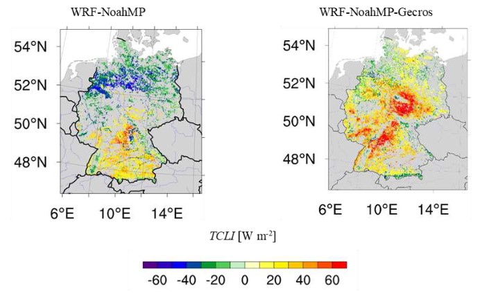
Atmospheric models employ an interface between the land surface model and the atmospheric boundary layer (ABL) flux parameterization. Via a surface layer scheme, momentum, heat and moisture fluxes are exchanged between the surface and the lowest atmospheric model layer. In this approach a blending height is introduced where the surface fluxes above a heterogeneous land surface are considered as homogeneous at the grid scale. At this height assumed within the lowest atmospheric model layer, the transition to the ABL parameterization takes place. However, for convection permitting (CP) model simulations (grid scale < 3 km) over heterogeneous vegetation, the lower model layers can be below the blending height leading to errors in the simulated fluxes. A major challenge in atmospheric modelling is to parameterize the interface between heterogeneous dynamic vegetation and ABL in unstable, stable and neutral conditions with advection from different wind directions. Accordingly, our objectives are the identification of the blending height in dependence of vegetation heterogeneity and states and of atmospheric framing conditions and the quantification of the impact of vegetation heterogeneity on the energy fluxes at the blending height. The results will be used to derive representative, scale-dependent fluxes at this level for land-atmosphere (L-A) feedback studies and turbulence parameterizations. WRF-NoahMPGecros model simulations from the CP to large eddy simulation scales will be compared with observations at LAFO and MOL-RAO sites to identify the blending height and effective vegetation roughness parameters for CP simulations in dependence of atmospheric framing conditions. The simulations will be embedded in the Multi Model Experiment (MME) via the Cross Cutting Working Group (CCWG)-MME. The impact of heterogeneity on the strength of L-A feedback will be investigated and the understanding of exchange processes between the surface and the atmosphere as well as within the ABL will be advanced. The synergy of these model results and 3D observational data will be used to study the scale dependent impact of dynamic vegetation heterogeneity on energy fluxes at the blending height.
P 8
Scale interaction in Land-Atmosphere (L-A) feedback
Earth-System Models (ESMs) are the most important tools for global climate projections under various future emissions and land-use scenarios. Yet they feature biases, in particular with respect to turbulent heat fluxes, that could not be resolved over the last decade. These biases raise fundamental questions but are equally relevant for very applied and urgent questions, since they are relevant in particular for heterogeneous landscapes – which include many of the world’s typical agricultural and forestry landscapes, where people live, grow food and hope to sequester CO2 as required by many climate-neutrality pathways. It remains unclear how different vegetation states and types, such as different land uses, affect the land-atmosphere coupling under realistic conditions, and how much biases in global modeling are attributable to low resolution versus other shortcomings of these models.
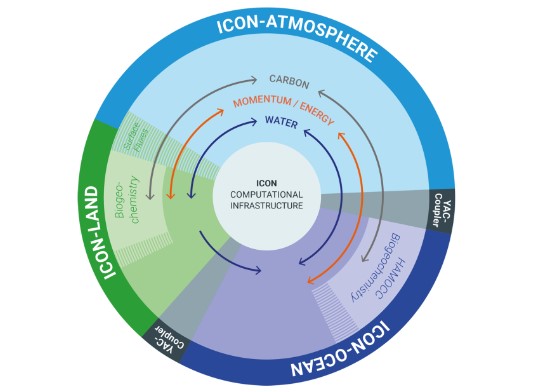
Our project aims at a better understanding of the role of surface heterogeneity in land-atmosphere coupling and plans to test its relevance in case studies guided by detailed, high-quality observations. We aim at closing the methodological gap between global ESMs and small-scale Large-Eddy Modeling (LEM) with respect to vegetation-atmosphere interactions by using the same land surface component – JSBACH4, a part of the ICON-ESM (Jungclaus et al. 2022). JSBACH includes a full functionality of vegetation processes, including land-use and land management aspects, and connects physical climate interactions with biogeochemical fluxes. This will provide the means to directly investigate if resolving the land-atmosphere interactions at high spatial detail will avoid strong known biases of ESMs like biases in turbulent heat fluxes, and how this depends on atmospheric conditions. With the help of high-resolution simulations, we will infer conclusions about the net climate effect of land use (i.e., when water, energy and CO2 fluxes are considered together) at a level relevant for decision-making.
P 9
Impact of terrestrial hydrology on L-A feedbacks and isotope signatures
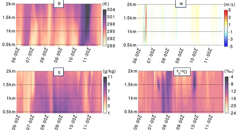
L-A feedbacks depend on the exchange of water between the land and the atmosphere and more generally on L-A water pathways. A sound understanding of the processes related to L-A water pathways requires a joint measuring-modeling effort and the consideration of a great variety of both terrestrial and atmospheric variables, as they are offered by the LAFO observatory and LAFI. We will particularly consider stable water isotopologues and focus on the role of terrestrial hydrological processes on L-A feedbacks. The research objective of P9 is to improve our understanding of the relationship and interactions between groundwater, soil moisture in the unsaturated zone, ET partitioning, isotope signatures and L-A feedbacks. The research hypotheses of P9 are that the consideration of isotopes in a L-A system model allows to better constrain the partitioning between E and T, reduce systematic errors in simulated ET, and more accurately characterize L-A coupling strength. Our studies will be performed with the isotope-enabled version of the fully coupled atmospheric hydrological modeling system WRF-NoahMP-Gecros-Hydro-iso at turbulence permitting scales, which will allow to represent the isotopic fractionation processes associated with E and T at a relevant scale for comparison to in-situ isotope observation.
P 10
Machine Learning for improved understanding of L-A processes and feedbacks
The LAFI consortium will generate excessively large amounts of data in form of observations and model outputs of the L-A system with unprecedented detail and resolutions. Understanding the processes and feedbacks underlying this complex data is a challenging task, as the atmospheric flow is chaotic in nature. The actual interactive complexity of turbulence dynamics within the atmospheric boundary layer and entrainment fluxes is still poorly understood. The highly non-linear interaction between many variables of the L-A system is therefore difficult to describe.
In recent years, deep learning (DL) methods were developed and tailored to identify hidden internal structures from large amounts of complex data. In the realms of LAFI, these capabilities of DL will be exploited to extract systematic interrelations underlying the processes and feedbacks in the L-A system. More precisely, we will 1) develop hierarchies of machine learning approaches and apply importance weighting techniques to identify key driving parameters and variables; 2) enhance DL and other machine learning techniques with physics-informed mechanisms; 3) include L-A system-informed inductive biases in DL, and 4) develop a DL-based foundation model, which will target the inference of general, L-A state characterizing structures. In this respect, we aim for an improved representation of relationships, the identification of unknown structures, and an improvement of process understanding.
P 11
Effect of land-atmosphere coupling on vegetation behaviour
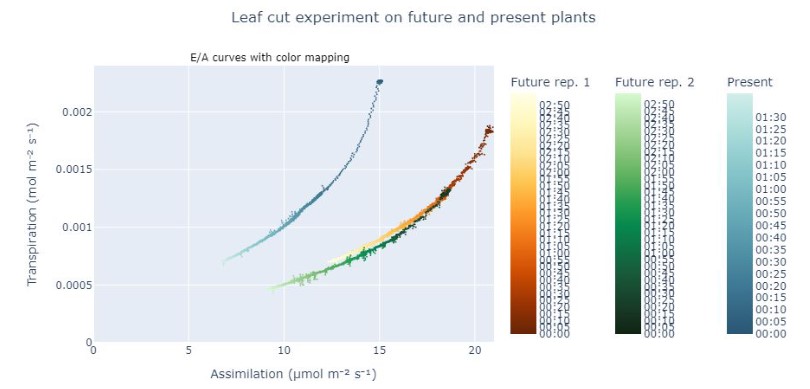
This project investigates the effect of land-atmosphere (L-A) coupling on vegetation water use and photosynthesis. It integrates controlled laboratory and field experiments with continuous monitoring of within-canopy micro-meteorological conditions and plant drought stress, with the specific sub-objective to represent the role of land-atmosphere coupling in an optimality-based vegetation model. The project will improve our understanding of stomatal control on transpiration and phosynthesis, extending observations of L-A feedback down to the canopy air space, and investigating the effect of extreme heat and/or drought on stomatal control and hence transpiration, with its ramifications for sensible heat flux and potential long-term effects due to heat damage to foliage. A specific focus will be put on 1) the effects of vertical mixing of air on leaf and canopy water use efficiency, 2) the effects of vertical mixing of air on leaf temperatures and thus on plant heat stress (especially during dry periods), 3) the potential to improve the simulation of transpiration, soil water dynamics and CO2 assimilation by optimality-based vegetation dynamics and stomatal control compared to conventional parameterizations of vegetation and stomatal dynamics.